


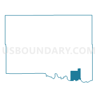
Voting District 306, Canadian County, Oklahoma
About
Outline

Summary
| Unique Area Identifier | 653620 |
| Name | Voting District 306 |
| County | Canadian County |
| State | Oklahoma |
| Area (square miles) | 15.83 |
| Land Area (square miles) | 15.07 |
| Water Area (square miles) | 0.77 |
| % of Land Area | 95.16 |
| % of Water Area | 4.84 |
| Latitude of the Internal Point | 35.36455940 |
| Longtitude of the Internal Point | -97.79323760 |
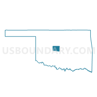
Maps

Graphs
Select a template below for downloading or customizing gragh for Voting District 306, Canadian County, Oklahoma


Neighbors
Neighoring Voting District (by Name) Neighboring Voting District on the Map
- Voting District 18, Grady County, OK
- Voting District 224, Canadian County, OK
- Voting District 226, Canadian County, OK
- Voting District 30, Grady County, OK
- Voting District 302, Canadian County, OK
- Voting District 304, Canadian County, OK
- Voting District 305, Canadian County, OK
- Voting District 400, Canadian County, OK
- Voting District 41, Grady County, OK
Top 10 Neighboring County Subdivision (by Population) Neighboring County Subdivision on the Map
- East Canadian CCD, Canadian County, OK (86,541)
- El Reno CCD, Canadian County, OK (26,531)
- Tuttle CCD, Grady County, OK (15,076)
Top 10 Neighboring Place (by Population) Neighboring Place on the Map
- Oklahoma City city, OK (579,999)
- Mustang city, OK (17,395)
- Tuttle city, OK (6,019)
- Union City town, OK (1,645)
Top 10 Neighboring Unified School District (by Population) Neighboring Unified School District on the Map
- Mustang Public Schools, OK (46,023)
- Tuttle Public Schools, OK (8,069)
- Union City Public Schools, OK (1,643)
Top 10 Neighboring State Legislative District Lower Chamber (by Population) Neighboring State Legislative District Lower Chamber on the Map
- State House District 43, OK (44,484)
- State House District 47, OK (41,973)
- State House District 56, OK (35,524)
Top 10 Neighboring State Legislative District Upper Chamber (by Population) Neighboring State Legislative District Upper Chamber on the Map
- State Senate District 24, OK (98,936)
- State Senate District 45, OK (85,350)
- State Senate District 23, OK (80,676)
Top 10 Neighboring 111th Congressional District (by Population) Neighboring 111th Congressional District on the Map
Top 10 Neighboring Census Tract (by Population) Neighboring Census Tract on the Map
- Census Tract 9.03, Grady County, OK (9,327)
- Census Tract 3007, Canadian County, OK (6,173)
- Census Tract 9.02, Grady County, OK (5,749)
- Census Tract 3014.07, Canadian County, OK (5,103)
- Census Tract 3013, Canadian County, OK (4,483)
- Census Tract 3014.08, Canadian County, OK (1,921)